Web Maps for WordPress is the best way to quickly and easily search for and…
| Author: | GEO-Jobe GIS Consulting (profile at wordpress.org) |
| WordPress version required: | 4.6 |
| WordPress version tested: | 5.9.3 |
| Plugin version: | 1.5 |
| Added to WordPress repository: | 19-08-2013 |
| Last updated: | 12-05-2022 |
| Rating, %: | 84 |
| Rated by: | 5 |
| Plugin URI: | https://www.geo-jobe.com/wordpress-plugin-for... |
| Total downloads: | 16 620 |
| Active installs: | 300+ |
 Click to start download |
|
Quickly and easily search and add interactive maps to your pages and posts with the “Add Web Map / App”, “ArcGIS Content Tree”, and “Add Content Slideshow” blocks. All of the features previously found in the Web Maps for WordPress Pro plugin are now integrated into this plugin for free!
Integrate the power of “where” into your pages and posts with interactive maps exposing authoritative content. Designed to bridge the gap between authoritative maps registered with ArcGIS Online and WordPress.
Functionality
While editing pages or posts, you’ll notice the addition of “Add Web Map / App”, “ArcGIS Content Tree”, and “Add Content Slideshow” blocks. The “Add Web Map / App” block is designed to provide WordPress users with a more streamlined process for embedding ArcGIS web maps, web applications, Story Maps and Dashboards in their pages and posts. The “Add Web Map / App” block puts millions of interactive maps at the fingertips of bloggers, website creators, media outlets and news organizations. For the first time, millions of WordPress users will be able to seamlessly enhance the information they’re communicating with authoritative maps exposing authoritative content from authoritative sources.
The following outlines various features of the “Add Web Map / App” block:
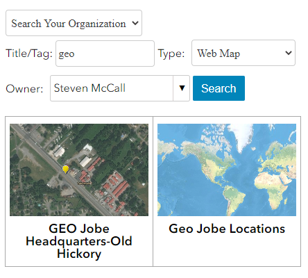
Searching for Maps:
- Search millions of interactive web maps using one or more keywords.
- All public web maps registered with ArcGIS Online that have a name or contain tags matching your keywords will be returned.
- Search results will be displayed in a grid-view showing the name and image of the map.
- Maps provide additional details (owner, description, etc.) that will help to inform users on whether or not this map is showcasing the right content.
- A map details link will take you to the ArcGIS Online item details page where a variety of additional information about this map is available.
Configuring Maps:
- Once a map has been selected, the user is presented with a variety of settings that can be configured before the map is embedded.
- Size, Show Zoom Control, Show Scale Bar, Show Legend, Show Description, Show Location Search, Show Basemap Selector
- Set your own custom map extents and create a map marker to display.
Viewing Maps:
- Embedded maps are fully interactive, which means that users can zoom in/out and identify features on the map.
- All visible data and capabilities exposed on each map layer are controlled within ArcGIS Online by the map creator.
- For layers with pop-ups enabled, users can click on features to see additional information in a pop-up dialog.
- Additional map controls exposed to the user (scale bar, legend, etc.) are determined on the WordPress side by the map settings.
Add Content Slideshow:
- The “Add Content Slideshow” block is designed to provide WordPress users with a slideshow of selected maps and apps (Web Maps, Web Mapping Applications, Story Maps and Dashboards) in order to highlight the work of their organization.
- Add Content Slideshow creates an attractive, easy to use slideshow, which will scroll through embedded apps and maps automatically but can also be controlled by the user.
- The item’s title at the bottom of each slide contains a link to open the item in a separate window.
Add Content Trees:
- The content tree widget is designed to provide WordPress users with a means of showcasing items, from the primary organization, on a WordPress page and filtering the items through tree view listings
- The content tree widget is comprised of the Tree view and the Items summary page.
Configure
- After uploading the plugin.
- Click on “Settings” from the menu bar in your admin panel.
- Click the “Web Maps for WP” link to go to the plugin’s settings.
- Under the Account Settings” tab, insert your ArcGIS Online Organization’s URL
- Under the “Advanced Content Tree Widget Settings” tab enter your “Items Summary Page ID”. Leave blank if you are unsure.
- Click “Save Changes” button once all chances are finalized.
Contact
Go to https://geo-jobe.com or contact connect@geo-jobe.com for questions or to request demos of the Pro Version.
Support our vision to spread the use of GIS by engaging with our blog at https://www.geo-jobe.com/blog/
Disclaimer
Our company accepts no liability for the use of Web Maps for WordPress, or for the consequences of any actions taken. Any use of Web Maps for WordPress for illegal activity is strictly prohibited. Any views or opinions presented in Web Maps for WordPress are solely those of the author and do not necessarily represent those of the company.
Screenshots
ChangeLog